[INFOGRAPHIC] These Drought Maps of California Show the Struggle is Real and Far From Over

Check out the latest edition of Food Drink & Franchise!
To say that California is a major force in agriculture would be an understatement—it’s the fifth largest food producer in the world and the largest in the United States and the country’s salad bowl, growing delicate fresh produce crops from artichokes to almonds that can’t be raised as widely and consistently anywhere else.
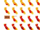
Of course, crops need an awful lot of water to grow. So to say that this drought map of California from 2011 to now is “troubling” would also be an understatement:
That’s a problem. How big of a problem exactly? According to reports, 75 percent of all California fresh water comes from the Sierra Nevada snowpack—at the moment, that snowpack is 20 percent of its usual size. Experts are already expecting the drought to cost California’s agriculture industry billions, and there’s no light at the end of the tunnel yet beyond conservation wherever possible.
So growers are finding new ways to conserve—it’s a process that some industry hubs like Salinas Valley have started on years ago with positive results. But conservation technology is probably going to have to progress rapidly in the next few years to keep up with the state of the land itself.
[SOURCE: Visual Capitalist]


